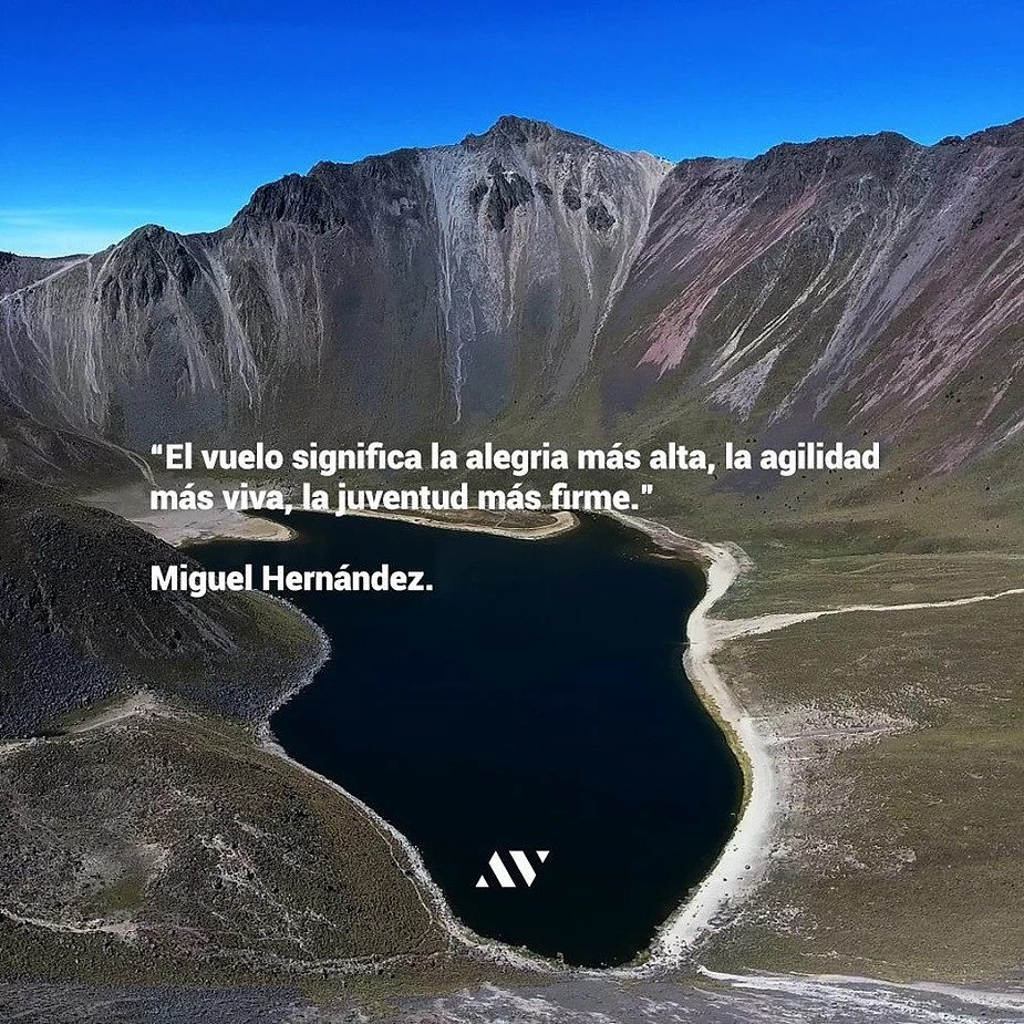
Posted on Leave a comment

Most frequent uses of Drones

We like to be updated and up to date with technology, we always look for the most practical and innovative application for everything in our life and drones are no exception.

Due to the different sizes that we can choose in a drone, we have the ability to fly in areas that were not possible before. That is, with unmanned aircraft we have absolute versatility about the shots we want to take, the areas we want to observe, the space we want to pass through and the benefits we want to bring to each area. Next, we present some of the most frequent uses of drones and you can get the most out of them.

home_1_descripción

Industrial:

To transform your operating model, companies are implementing technologies that facilitate daily reviews, safeguarding the safety of their employees, agilely monitoring high-risk jobs, complex works and environmental impact studies.


Drones have different types of cameras - Infrared / Thermal - to prevent or detect any kind of incident in areas of difficult access. In case it is impossible to pay for a service or the use you require is frequent to hire a service temporarily, it is advisable to make a personal team and train for its use and proper handling, so you can generate the air material you require.

in_2

Infrastructure:

With drones it is possible to monitor processes and work progress, make photogrammetry surveys in dangerous or difficult to access areas (3D model) and generate valuable images and videos, both for your company and for your clients. For the dissemination and sale of projects in print and digital media, you can also create 360 virtual reality for the promotion of your facilities. It is the future of new technologies!

if_1

Sport:

To document and transmit live sporting events is to capture the action in each play with images of the highest quality and from a complete and integral perspective of what happens at ground level. Through the contents generated with drones and the assistance of cameras on the floor, you will have a clearer idea of the skills of each athlete, while showing the greatness and beauty of the sports facilities.

Record workouts and having help to get the most out of any team when doing sports scouting.

The benefits do not end!

d_2

Advertising:

Advertising agencies, production houses and audiovisual companies that need a raw aerial video from a novel angle or a creative perspective. Producing audiovisual projects tailored with drones is now more efficient and economic: The drone is a crane, a steady, a dolly and a helicopter. Including drones in virtual reality with 360 cameras is the future. Know the range of drones that exist in the market and become more attractive in the exposure of your brand.

galery_11

Social:

Cover concerts, festivals, parades, weddings and events of any kind: Complement the generation of audiovisual content with floor cameras and drones for the realization of your video is the best way to give exposure. The air content will make you relive and share memorable moments.

s_1

The benefits that drones can bring to your projects are unimaginable and this is just beginning. AV Drones has services for any of these projects ranging from advice, flight and management of shots, training and equipment acquisition: We are aerial solutions and your option to materialize any idea with floor cameras and drones.

Explore the benefits that drones can provide to your projects with AV Drones.

Join the digital era and create content that makes you fly!

Posted on Leave a comment

What is a drone?

A drone is an unmanned aerial vehicle.Its name is derived from the English drone, which in Spanish is translated as: "male bee". There are drones of different sizes and with different purposes for a long time, but their manufacturing cost was very high for large scale commercialization and did not have the characteristics they currently have.

dron_sobre_el_agua

The main characteristic of a drone is that its flight is controlled remotely. Some through the intervention of software and others directly through a pilot who directs it from the ground.


TYPES OF DRONES


Drones can be of two types. Those that resemble an airplane: take off, follow a trajectory in the air and land; and those that look like a helicopter: These have the same characteristics as the first, but are able to stay static in the air.


These can also be differentiated by their types of platforms, which are basically of two types: fixed wing and rotating wing; The fixed wing has the appearance and shape of a model airplane and the rotary wing is divided into two types: helicopters and multirotors.


Multirotors are the most popular tool currently and the one we commonly have in our minds when thinking of a drone. This design provides great versatility and efficiency in operations due to its simplicity in the controls at the time of being piloted and the speed of assembly. It is a stable platform by nature, because the engines are at the same distance from the center of gravity of the aircraft.

According to the number of engines we can also classify them as follows: in trichopters (3 engines), quadcopters (4 engines), hexacopter (6 engines) and octocopter (8 engines); and according to the configuration of the arms its classification is: in "Y" (Greek i), " Y inverted" (inverted Greek i), "X", "+" (cross).


On the other hand, there are also coaxial multirotors - that is, two motors per arm. This provides a saving in the weight of the apparatus by having half the arms but, on the contrary, aerodynamic efficiency is reduced. When choosing between a multi-rotor or another, we must take into account that more arms represent greater stability and greater safety, while more engines represent greater propulsion and, therefore, higher battery consumption.

galery_10

Currently, the advantages of using drones are many thanks to the technology that has been developed, and due to its different sizes and capacities it is possible to fly, assess and visualize all kinds of areas and routes that in the past were inaccessible.

With unmanned aircraft we have absolute freedom and versatility to generate graphic shots of infinity of areas and terrains that we want to observe and visualize, dictating and choosing with total freedom the route and the space for which we want to travel.

There is no tool more versatile than a drone to generate visual content and perform tasks that until now implied a high investment of resources for its realization. The creative and technological capabilities of a drone are endless and applicable to any type of project. The advantages (in price, management, operability, etc.) are substantial compared to other tools and methods.


Explore the benefits drones can bring to your projects with AV Drones!

References:

Posted on Leave a comment

Faro Cancun in Drone

FARO CANCÚN

At present, the use of lighthouses is almost obsolete thanks to the use of GPS navigation systems. In Mexico, however, currently operate 135 along the coasts and coast of the nation, are a historical legacy and symbol of cultural identity.

Depending on its use, there are three types of lighthouses: 1) those of landfall that facilitate the arrival of ships; 2) Intermediate, they work as complements of lighthouses of arrival, they are in the coasts and offer aid to the navigator; and 3) situation, and serve to indicate accidents or risk situations for navigation (Government of the Republic, 2017).

p_1

The lighthouse of Costa Cancun is iconic of the hotel zone, a place recognized for its harmony and beauty that allows you to enjoy and capture unforgettable postcards. Supposedly it is a place of public access -as- according to Mexican legislation, the beaches are federal property and free of traffic (Luckie, 2018).

Accessing the lighthouse can be complicated, since there are no free passes due to the excessive sale of lots and uncontrolled hotel construction; If you try to enter the beach, the nearest access is through Playa Caracol. In an interview with Helena Hernandez, Tiziana Roma mentions the following (2018): "little by little, access to the beach has been limited to citizens (...) previously the first inhabitants of Cancun could freely enjoy the beaches, but now it seems that the population was strange or foreign and each time has less opportunity to enjoy it ".


Let's take care of what we have, this is Mexico.

faro_1

Explore the benefits drones can bring to your projects with AV Drones!


References:

Posted on Leave a comment

Drones and Environment

DRONES Y MEDIO AMBIENTE

En los últimos 15 años ha aumentado el uso de drones para el monitoreo de la vida silvestre y su hábitat, con ellos se pueden obtener mapas en alta resolución, información para conocer el estado atmosférico, evaluación del impacto de obras y planificación urbana, vigilancia, etc. Esto a un bajo costo en tiempo y recursos, y con la posibilidad de tener información valiosa en cualquier época del año. Su uso se enfoca en particular a la fauna sensible en zonas poco accesibles o para especies raras de difícil detección u observación. Las rutas de navegación de los drones se pueden programar previamente, al igual que las zonas de despegue y aterrizaje, por lo que la información puede ser recaudada prácticamente de manera automática.


Deforestación

Los drones pueden ayudar con actividades relacionadas al cultivo, cuidado y explotación de los bosques y montes (silvicultura). Como lo muestra el ingeniero Lauren Fletcher de la Universidad de Oxford, quien diseña drones capaces de llevar a cabo siembras masivas de árboles para combatir la deforestación esparciendo semillas desde el aire. También son muy eficientes para detectar incendios y determinar con precisión la zona de fuego para extinguirlo de manera efectiva.

Los drones pueden ser útiles herramientas para medir la contaminación del aire, detectar áreas de deforestación, ayudar a la aplicación de pesticidas y fertilizantes, monitorear bosques, selvas, y hasta vigilar las costas marinas para detectar posibles riesgos y visualizar desastres e impactos naturales. Pueden capturar imagines durante 24 horas para una supervisión constante en tiempo real.

Protección de la vida silvestre

Desde el aire, un dron se pueden cuantificar las especies de flora y fauna, realizar descripciones de paisaje y detectar actividades humanas que impactan los ecosistemas. Las reservas naturales los utilizan para protegerlas y vigilarlas de cazadores furtivos; previenen ataques, adquieren evidencia para procesos legales o son utilizados como elemento disuasorio.

Fotografía tomada con cámara infrarroja.

También pueden localizar y monitorear la actividad de animales a través de geolocalizadores que funcionan en tiempo real. En concreto, esta tecnología ha sido utilizada en los parques nacionales de Namibia para la protección de elefantes y rinocerontes, incluso se han utilizado para identificar nidos y camas de orangutanes y madrigueras de roedores.

Utilizar drones en pro del medio ambiente es fundamental en nuestros días. El acceso a hábitats poco estudiados, la observación de especies difíciles de filmar o la posibilidad de sobrevolar situaciones complejas es ahora posible.

Explore the benefits drones can bring to your projects with AV Drones!

Explore the benefits drones can bring to your projects with AV Drones!


References:


Posted on Leave a comment

Nevado de Toluca in Drone

NEVADO DE TOLUCA

Also known as Xinantécatl, which means "naked man" in Mixtec language. It is the fourth highest peak in Mexico (4,680 m), a volcano located in the State of Mexico, between the valley of Toluca and the valley of Matlatzinco.

According to experts, 25 million years ago the height of this volcano was 6,000 m and it had glaciers on its tops; it is estimated that the first time it erupted was 30,000 years ago and formed its crater, 11,000 years ago another great eruption occurred that the west side of the crater disappeared, and sometime later, in the center, a hill was formed which was named “El Ombligo”, this formation divided the crater into two parts that with the thaw became the lagoons of El Sol and La Luna. (Unión Edomex, 2018).

At the beginning of the 20th century, the most extensive agrarian reform in Latin America took place in Mexico, distributing two thirds of the national territory in the form of ejidos. It was not until 1980, with the establishment of the neoliberal economic model, that the progressive withdrawal of the State from agricultural development policies began, opening the land to privatization. (Tuscany, 2015).

blog1

On October 1, 2013, under the presidency of Enrique Peña Nieto, a decree was published in the Official Gazette of the Federation that modified the status of the Nevado de Toluca National Park that President Lázaro Cárdenas had established in 1936 to the Protection Area of Flora and Fauna as follows: the total area of the protected area (53 thousand 590 hectares) was divided into two zones:

The core (1 thousand 941 hectares) -which has greater ecological importance- is a restricted area of conservation activities ; the second part, the buffer part (51 thousand 649 hectares) was determined as an area where activities of extractive use of wildlife and forest management are allowed.

blog2

This generated tensions with the ejido of Loma Alta, since its recategorization implies new rules around the use of natural resources and activities, waiting for the farmers to modify their activities or to emigrate. (Tuscany, 2015). Eduardo Arenas and José Eseverri point out that the forest and its inhabitants should be understood as an ecosystem and not as isolated entities that are determined by the status of legal protection granted to them, and that community forests have proven to be a viable option for achieve environmental, social and economic benefits; the protection and sustainability of the environment become crucial for the community that lives from it. Of the agrarian nuclei that have forest land, 2 thousand 300 have forestry management plans, 4 thousand communities started conservation programs between 2009 and 2013 and there are more than 600 thousand hectares certified for good management.

Protecting in a responsible manner and using resources appropriately is essential at present. To achieve sustainability in natural landscapes it is vital to take into account the reality in which people live, considering harmony with the environment.

Explore the benefits drones can bring to your projects with AV Drones!


References: